Tools and a location system are key in the process of navigation. Tools could be anything from the stars in the night time sky to an expensive GPS unit. A location system is important in finding out where you are during navigation. A location (coordinate) system can use latitude and longitude or other forms of geographic scales, depending on the scale of navigation. Different coordinate systems are used depending on the study area to provide better accuracy in determining a location. The purpose of this lab is to create two navigation maps using two different coordinate grids.
Study Area
The Priory is a dormitory belonging to the University of Wisconsin - Eau Claire. This dorm is nestled in a wooded area located roughly 2.25 miles SSW of the University (Figure 1).
 |
| Figure 1. The priory is about a 10 minute drive from the university. |
Two maps were created in ArcMap with each using different coordinate systems. They share the same 3 meter contours and base map. One map was created using a Universal Transverse Mercator (UTM) Coordinate System and the other uses a Geographic Coordinate System (GCS). The data can be found in the class share folder in the Priory geodatabase.
UTM
This coordinate system divides the globe into 60 north and south zones. Each zone has its own central meridean with the equator dividing the north and south zones (Figure 2).
 |
| Figure 2. This image shows the UTM zones found in the United States. Image from Wikipedia. |
This coordinate system uses latitude and longitude in decimal degrees(Figure 3). While the UTM uses the transverse mercator the GCS is not attached to any particular projection.
 |
| Figure 3. The distance represented by one degree of longitude decreases as the meridians converge at the North and South Poles. Image provided by ArcMap Desktop Web Help. |
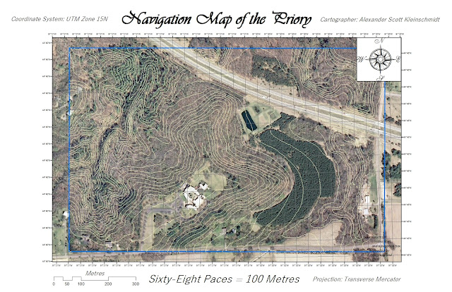
The first map (Figure 4) uses the WGS 1984 UTM Zone 15 N projected coordinate system. The second map (Figure 5) uses the WGS 1984 geographic coordinate system. The geographic coordinate system produces more distortion in the image, so it would be better suited for navigation.
 |
| Figure 4. This map grid uses 50 meter spacing. |
 |
| Figure 5. This map grid is in decimal degrees. |
This lab showed that creating a navigation map requires a more practical map setup. This set up must be easy to read so that the user can navigate using this along with a basic compass. Navigation maps are important in times when technology such as GPS aren't an option. The grid and elevation contours are added to help users visualize the landscape. The UTM grid will prove most useful in the next lab.
No comments:
Post a Comment